Eagle Eye
Improving Multiple-Image Super-Resolution for Mobile Devices through Image Alignment Selection

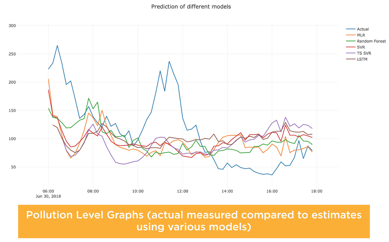
In the National Capital Region of the Philippines, air pollution levels are 70% higher than what is considered safe by WHO air quality guidelines. One main cause of this is the pervasive use and increasing number of vehicles in the region. In other countries, monitoring stations and emissions models have aided air quality planning and policy making. However, acquiring and maintaining air quality monitoring stations are costly. Usage of an existing vehicle emissions model for quantifying high-quality emissions measurements requires in-depth adjustments and calibration of the model. As such, this study proposes an alternative and low-cost way to estimate air quality. A roadside air quality estimation system that considers the context of Philippine land transport will be explored and developed. In order to do this, statistical and machine learning techniques will be used to model several criteria pollutants. The system will be created using the vehicle counter and classifier of VEMON, a vision-based vehicle monitoring system, and meteorological, and air quality measurements along the De La Salle University- Manila, Taft Avenue, Manila.
This research aims to create a speed detection system that can automatically calibrate to scenes with vehicles moving in multiple directions. Specific areas such as intersections and curved roads satisfy the condition of multi-directional movement. There is a substantial amount of research on calibration and speed estimation, however, existing methods only focus on vehicles moving in straight lines. In this paper, the current approaches on calibration and speed estimation are investigated and a novel approach for calibrating on multi-directional vehicle movement is proposed. Two vanishing points are detected from the scene. The first vanishing point is detected by a Cascaded Hough Transform. Previous works detect the second vanishing point using edges from vehicles. However, this does not work if the vehicles are not aligned with the perspective. Hence, to detect the second vanishing point, a multiple regression fit is used to derive the horizontal position of the second vanishing point from the location of the first vanishing point. To further handle multi-directional movement, motion lines from vehicle movement are used to detect the alignment of vehicles and the dimensions of the bounding boxes are adjusted accordingly based on the detected alignment. Results show that the system is able to calibrate to different perspectives and estimate the speed of the vehicles. The estimated distances from the calibration process have an average absolute error of about 1.87 meters and an average relative error of 18.56%. This translates to a speed estimation error of plus or minus 6.74 kilometers per hour.
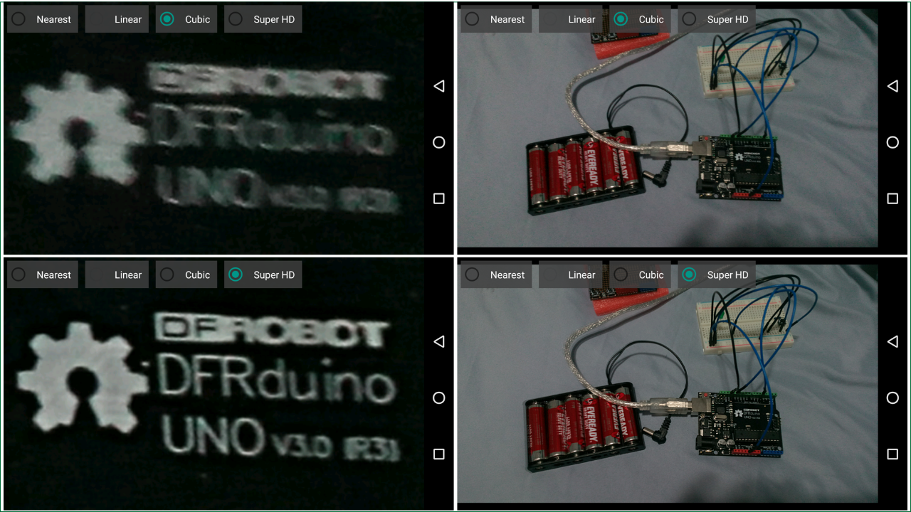
Multiple-image super-resolution (MISR) attempts to recover a high-resolution (HR) image from a set of lowresolution (LR) images. In this paper, we present a mobile MISR tailored to work for a wide range of mobile devices. Our technique aims to address misalignment issues from a previous work and further enhance the quality of HR images produced. The proposed architecture is used to implement a prototype application that is freely available at Google Play Store, titled Eagle-Eye HD Camera. The system is divided into the following modules: Input Module, Edge Detection Module, Image Selection Module, Image Alignment Module, Alignment Selection Module and Image Fusion Module. We assessed the quality of HR images produced by our mobile MISR, through an online survey, as well as compare it with other related SR works. Performance time was also measured. A total of 114 respondents have participated in the survey, where majority of respondents preferred our approach. Our approach is observed to be comparable with other SR works in terms of visual quality and performance time, and guaranteed to work in a mobile environment.
Recently, the pervasiveness of street cameras for security and traffic monitoring opens new challenges to the computer vision technology to provide reliable monitoring schemes. These monitoring schemes require the basic processes of detecting and tracking objects, such as vehicles. However, object detection performance often suffers under occlusion. This work proposes a vehicle occlusion handling improvement of an existing traffic video monitoring system, which was later integrated. Two scenarios were considered in occlusion: distinct and indistinct - wherein the occluded vehicles have similar and dissimilar colors, respectively. K-means clustering using the HSV color space was used for distinct occlusion while sliding window algorithm was used for indistinct occlusion. The proposed method also applies deep convolutional neural networks to further improve vehicle recognition and classification. The CNN model obtained a 97.21% training accuracy and a 98.27% testing accuracy. Moreover, it identifies common vehicle types rather than classifying these as small, medium and large vehicles, as well as minimizing the effect of occlusion to vehicle detection and classification. The integrated system had a runtime of 26 seconds for a 6-second video with 3 blobs, 71 seconds for a 25-second video with 5 blobs, and 224 seconds for a 42-second video with 6 blobs. The machine that was used for testing the integration of VeMon and Vsion has an Intel® i5 Generation i5-3320M @ 2/0GHz Dual Core processor, 8GB DDR3 RAM, and a storage of 120GB. Despite the implementation and results, it is recommended to improve the occlusion handling issue. The disadvantage of the sliding window algorithm is that it requires a lot of memory and is time-consuming. In case of deploying this research for more substantial purposes and intentions, it is ideal to enhance the CNN model by training it with images of vehicles outside De La Salle University-Manila and to implement the system real-time. The results of this work can serve as a contribution for future works that are significant to traffic monitoring and air quality surveillance.
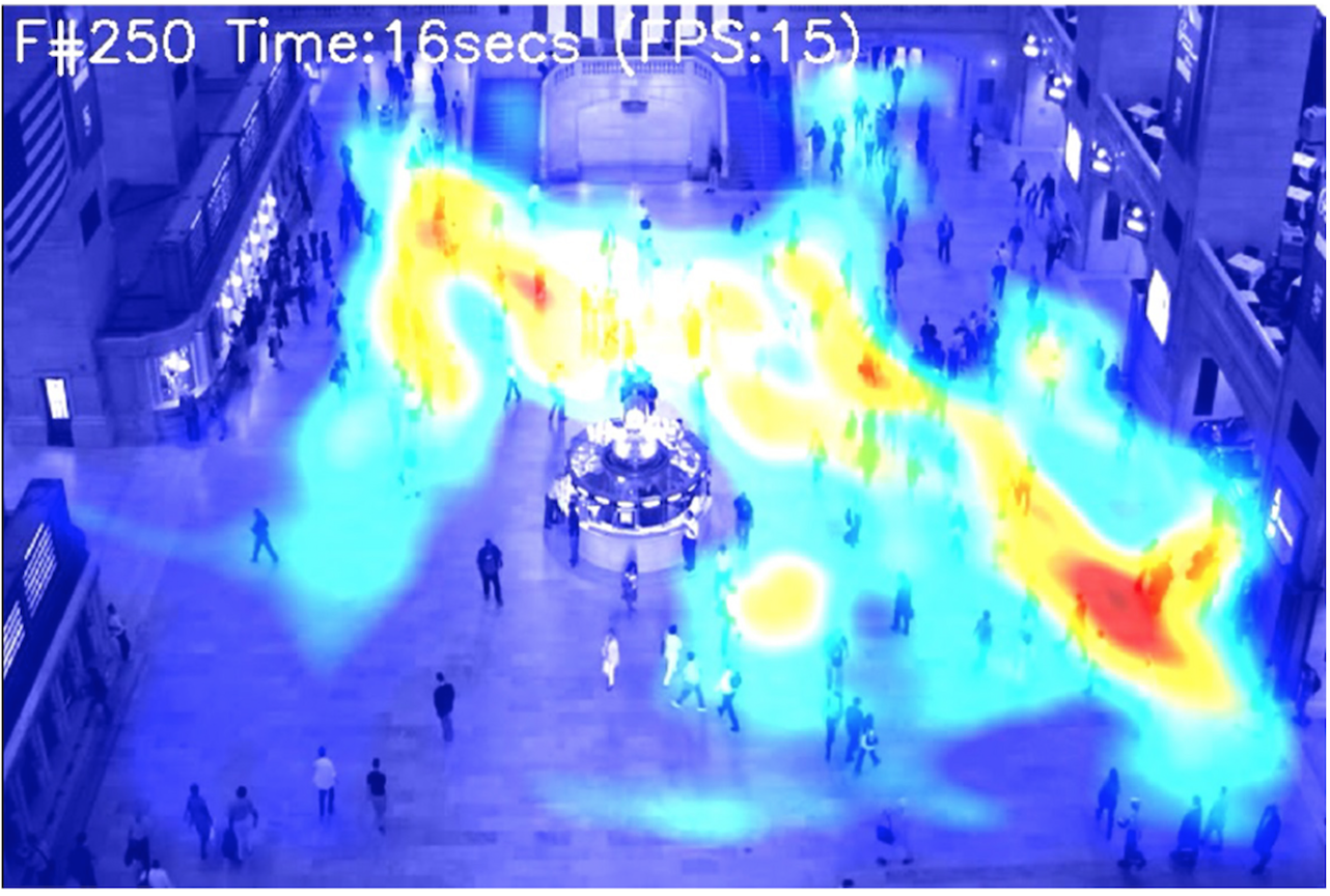
According to Land Transportation Office (LTO) on the year 2011, 2012, and 2013 the number of motor vehicles registered were approximately seven million. Every year, there is an increase in registered vehicles that will result in difficulty on providing better traffic management systems. The proposed solution is to develop and expand on the previous study named TraVis in order to monitor vehicle flow and enable analysis of the possible causes of traffic in the respective areas. TraVis is a traffic monitoring system that makes use of a web-based environment and utilizes accessible traffic surveillance videos to provide information to users about relevant traffic information. The performance of TraVis can be further improved by addressing the problems of their detection, tracking, illumination, and inconsistent background modelling. Along with improving TraVis’ data generation and data aggregation, allowing more granular data viewing and longer traffic data coverage. The study focuses its location on the Archer’s eye primarily on the Andrew and Gokongwei building location. The generated count of the study in Andrew and Gokongwei, results in getting an error rate of 12.40% and 23.9% respectively in light traffic condition, 26.03% and 23.99% for moderate traffic condition, and 27.82% and 31.39% for heavy traffic condition. To determine the congestion level, the system uses SVM modelling. Using it in light, moderate, and heavy traffic condition showed 100%, 48% and 100% accuracy respectively for Andrew location, while it showed 100%, 84% and 60% accuracy for Gokongwei location. The proposed traffic analysis algorithm can be summarized in five steps: (1) Background Modelling, (2) Moving object segmentation, (3) Vehicle detection and tracking, (4) Vehicle classification and counting, and (5) Vehicle speed.
Real-time data processing is an important building block in today’s fast-paced, interconnected, digital world. Infinitely many pieces of information are sent and received each day and often, these pieces of information are essential data that determines the operation of a modern metropolis. Society now relies on real-time data to make better solutions to problems such as heavy traffic and air quality degradation, two of the most common problems of a heavily populated city. However, as real-time technologies are implemented to address these problems, reliability has been an issue which shows why these problems still exist. One example is the accuracy of classifying vehicles. Using Support Vector Machine (SVM), Artificial Neural Network (ANN), and Convolutional Neural Network (CNN) yields 88.7%, 95%, and 95.7% classification rates respectively. The implementation of CNN resulted in a high accuracy rate for classification. However, CNN’s computational complexity is an issue when it is to be used in fast implementations. In this work, the implementation of vehicle type classification using CNN will be applied with the processing power of the graphics processing unit to be able to achieve a fast and reliable vehicle type classification system. The results of this work will advance other applications that rely on vehicle type information, such as real-time traffic and air quality monitoring.
Some traffic monitoring systems that have been deployed lack accessibility and understandability in terms of the information they provide. There are also cases where the traffic is not well monitored due to human limitations. With this in mind, TraVis is developed as a traffic monitoring system that makes use of a web-based environment and utilizes accessible traffic cameras with less human interaction. Systems that would serve as references in this research are VIVET and VISTA. VIVET is a vision based vehicle tracking system while VISTA is based on VIVET which focuses on data aquisition of traffic parameters. TraVis is a semi real time traffic monitoring system that tracks, classifies and countrs vehicles in a selected traffic video recorded trhough a traffic camera. Vehicle tracking was implemented using Kalman Filter to estimate the vehicle locations. Tracked vehicles are then classified into different types (sucha as small, medium and large vehicles) based from their area properties. A vehicle is counted the first time it is detected. Speed estimation was done in the form of traffic flow that was based on the number of tracked vehicles perminute with six 6 frames per second as the frame rate of the Archer’s Eye cameras. The videos that the users can choose from are the recorded traffic videos trom the DLSU Archer’s Eye obtained through the help od the Information Technology Services and the Administrators of the Archer’s Eye. The system utilizes its generated traffic statistics such as the vehicle counts per type and in total, the averate traffic flow as to how many vehicles have passed in the surveyed road section in one minute, and the estimated traffic congestion levels. Congestion levels are directly influenced by the number of vehicles tracked and their classification. Also, to address common challenges among traffic systems such as vehicle occlusions and varying lighting conditions, TraVis was designed to use an empty background model that is continuously updated every one minute of the recorded video. In testing TraVis for its vehicle detection, two types of background modelling was used: Frequent BG Modeling and One-Time BG Modeling. The Frequent BG Modeling showed 87.50% of accuracy in contrast to One-Time BG Modeling that only garnered -51.30% in accuracy.
Problems with existing traffic and surveillance and detection systems have led researchers to venture into the use of computer vision technology in traffic analysis. In order to be implemented in the Philippines, however, additional parameters need to be considered such as carious modes of transportation (i.e. bicycles, pedicabs, calesas), and some non-vehicle contributions to traffic, which include processions and rallies. In light of this, VISTA endavors to implement a multiple vehicle tracking and traffic analysis system based on Philippine roadways. The study focuses on implementing an data aquisition system necessary for traffic analysis. The input of the system is an image sequence. Each image is then processed to identify entities on the road that contribute to traffic. Once these entities are identified, traffic density and traffic flow are then computed based on the image sequence. The output of the system can be used as the necessary traffic parameters for traffic managament and information systems. The system is capable of detecting global brightness drops which are treated as shadows. The system can process at 3.22 frames per second for background modelling, and at 2.47 frames per second for result generation. Traffic density and traffic flow are directly influenced by the accuracy of the detection scheme. The accuracy of detection is 68.75% and is heavily dependent on how the system is calibrated.
The use of computer vision has started to make its way in the field of Traffic surveillance. Through video image processing, valuable traffic data such as vehicle count and density is generated automatically with minimal human intervention. To date, this technology has been adopted by many countries to break away from the manual surveillance system and the problems encountered by the conventional inpavement loops. However, here in the Philippines, this technology has not yet been adopted. More so, the performance of vehicle tracking approaches when implemented on Philippine roadways is still questionalble due to unforseen localized conditions. In this regard, ViVeT endavors the implementation od a multiple vehicle tracking system based on Philippine roadways. The study focuses on implementing a system that can track vehicles under roadways subject to varying levels of occlusion, shadow and luminance taking into consideration the localized factors relating to these identified problems. The system mainly consist od a video acquisition and a video tracking module. Prior to tracking, a still digital video camera records a video footage of a reoadway and converts it to an image sequence. The actual vehivle tracking then starts off with the processing of the image sequence to hypothesize and verify all possible locations of vehicles. With its successful implementation, the study can serve a s a platform for traffic surveillance purposes as well as those applications tht provide traffic information to motorists and commuters.